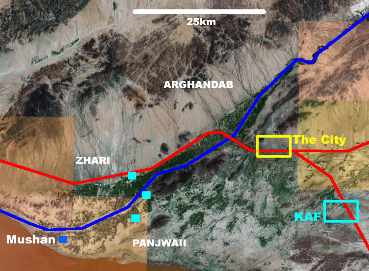
Kandahar province: "Let's go to the map"
Okay, so I wanted to explain a few things maybe about the recent closure of strong point Mushan. That, of course, required a little more explanation about our current theatre of operations. Not a lot of good maps online for that right now. But the best way to understand the Kandahar dynamic is really to look at an aerial photo, and for that Google Earth does just fine. So instead of Mushan specifically, this has turned more into an illustrated talk on battlespace geometry.Here's a map of the ring road--the road links Kabul/Kandahar/Herat/Mazar-i-Sharif/Kabul.The big thing you have to notice when looking at the Google Earth image of the Kandahar area is the green spaces. Because these are the only places with any life. The rest, all around, is inhospitable mountain and desert. Centuries of human intervention in the form of irrigation have carved a thin strip of arable land down the Arghandab valley (shown in blue). It is the green spaces, the Arghandab being by far the largest, where all economic activity goes on, and the 50% of Kandahar Province's 1-million population which does not live in the city itself resides. All else is waste land.
The valley is joined by a second human creation, the Afghan Ring Road (red). The paved thruway for all major human commerce, it goes right through the congested centre of Kandahar City (yellow box). Keeping this road open is an essential security function for both the Afghans and the coalition [more on roads here].Kandahar City, the key prize in all this, is defined by its proximity to these two major arteries. Controlling it gives you control of the economy and commerce of the entire south: the green spaces and the road. And vice versa.
For the last few years, most of the fighting in this area has been in the green spaces of Zhari (north of the river) and Panjwaii (south of the river) districts, with occasional forays into Arghandab district, northwest of the city, as well. The insurgents use the people and the lush terrain for cover, and have proven exceptionally difficult to remove by force. The Afghan army and its Canadian allies, whose main bases are centred around the old international airport to the southeast of the city (KAF) are largely, at this point in the game, ensconced in three large forward operating bases, or FOBs, (cyan squares) posing a barrier across the valley itself. To the west of this line within Zhari or Panjwaii is, basically, Indian country right now.
Dotted around these larger bases, and not shown here, are a number of strongpoints and police substations, manned by Afghan security forces and, in almost all cases, a small number of Canadian military mentors. These are the places where we and they have been attempting to practice doctrinal counterinsurgency, in fine Bing West, The Village, style. It's had a mixed record of success, obviously. And it is possible to get spread too thin, as we have proven. Both sizes have their pluses and minuses. A 100-man base has to devote a significant portion of its effective strength to protecting the base itself, rather than patrolling the countryside, whereas a 300-man base can force project a reaction force, etc., more easily. But it is fair to say that it is in the smaller bases, operating in company strength or less, where the Afghan army really punched above their weight, during our rotation, at least. A Canadian section and an ANA company-minus operating independently, at their best, are mutually supporting, each able to offset the weaknesses of the other (this is also mostly true of mentored police stations in this area, as well). Through the mentor team the Afghans have access to fire support, casualty evacuation, and so on, while through the Afghans the Canadians have access, real access, to the population itself, while the added strength in numbers makes the presence of a small number of Canadians sustainable in that area, indefinitely. When it works, it works really well.
You can get some of the same synergy at the larger joint bases, as well, of course, but the effect is less efficient. Patrols in this region, for a variety of reasons, tend to be dismounted, and once you're limited to walking distances those bigger bases lose a lot of their potential impact. (Hence the need for the smaller strongpoints in the first place: to expand your footprint.) As well, the larger bases are pretty well optimally sited now, after some experimentation: they're as permanent a fixture on the landscape as you're going to get in these districts. The smaller strongpoints are designed to be collapsible as the tactical situation ebbs and flows.
Hence Mushan, shown, way out at the western tip of Panjwayi. It had been established at a time (early' 07) when it appeared the insurgency was, if not on the wane, at least fundamentally changing from the stand-up-and-fight insurgency we had been fighting up to that point. And it, like a number of strongpoints established at that time, eventually proved unsustainable due to that insurgent change of strategy in Kandahar Province to predominantly an IED offensive, which has made it effectively impossible to drive supplies, etc. to Mushan for some time. At the end of a long helicopter ride from anywhere, at a time when helicopter assets were very difficult for Canadians to obtain (ironically, this is changing now due to American arrivals, only after the strongpoint has closed) it was as tough a hardship post for Canadians as existed in this theatre. It also did a great deal of good, with one of the ANA's largest weapons seizures and much of their useful intelligence coming from their companies that rotated through this location during our time there. That speaks to the effectiveness of the Bing West-style counter-insurgency work that was going on at that location, and the degree of faith and trust those soldiers had built within the villages in close proximity to the strongpoint. So does the fact that despite those successes, it was actually one of the more peaceful strongpoints we had. (That's relatively speaking, of course: shortly after that arms seizure insurgents struck back by mortaring the place, and 2 ANA soldiers were killed.) But it wasn't threat of insurgent overrun or futility of effort that made us decide to depart now. Given adequate spare helicopter lift or a reliable ground route, we likely could have stayed there forever.
That said, the closing of Mushan should be seen as a disappointment, albeit perhaps an inevitable one, and not just because of the likely consequences for our friends in the local population there. At a time when the Afghan army is really just getting off its feet, its fair to say a lot of its talent, or at least its more impressionable future leadership, is concentrated at the junior officer level. There are Afghan captains and lieutenants who are surprisingly good, or at least surprisingly ready to try new things with mentor support. Operating in company detachments effectively puts some of those future leaders out of the reach of their own senior officers, many of whom, either because they are old retreads from three Afghan armies ago, or have been promoted too fast in the rapidly expanding new ANA, are relatively less effective or capable in their positions. Saying you're concentrating your Afghan soldiers in larger bases like KAF or the FOBs puts more of them more within the daily control of colonels and generals instead of captains. Regrettably, any efforts to consolidate larger Afghan forces closer to the city right now will likely increase their chances of being misused.

Map of Road Development (phase 1) (courtesy of Asian Development Bank)
Click to enlarge.
By the way, keeping the ring road through downtown Kandahar flowing fairly freely for Afghan traffic will be a large challenge with the major increase in vehicular traffic that will ensue with the several orders of magnitude increase in foreign forces in the province as the US surge continues to arrive.
posted by Anonymous at 4:25 p.m.
![]()


0 Comments:
Post a Comment
<< Home